
In the decades that followed, America’s offshore energy industry pushed into deeper water and increasingly complex operating environments. That progress helped advance dynamic positioning, remotely operated vehicles, subsea systems, risers, geophysical surveying, heavy-lift capabilities, advanced vessels, and deepwater monitoring.
The Gulf of America became a proving ground for many of these technologies, as offshore companies developed the equipment, engineering expertise, and operating experience needed to work safely and reliably in deep water.
Today, technologies developed and refined through decades of offshore operations provide much of the foundation needed to explore and develop ocean minerals.
The challenge is adapting and integrating those capabilities for different mineral deposits, operating conditions, and environmental requirements.
The application is new. Much of the technology and offshore expertise behind it isn’t.
From the Surface to the Seafloor
Ocean mineral development is not a single technology. It is an integrated system stretching from vessels on the surface to equipment operating thousands of meters below.
Different mineral resources require different approaches. Polymetallic nodules rest on the seafloor, while cobalt-rich crusts and seafloor sulfide deposits are attached to harder geological formations. Those differences influence how resources are surveyed, evaluated, and potentially recovered.
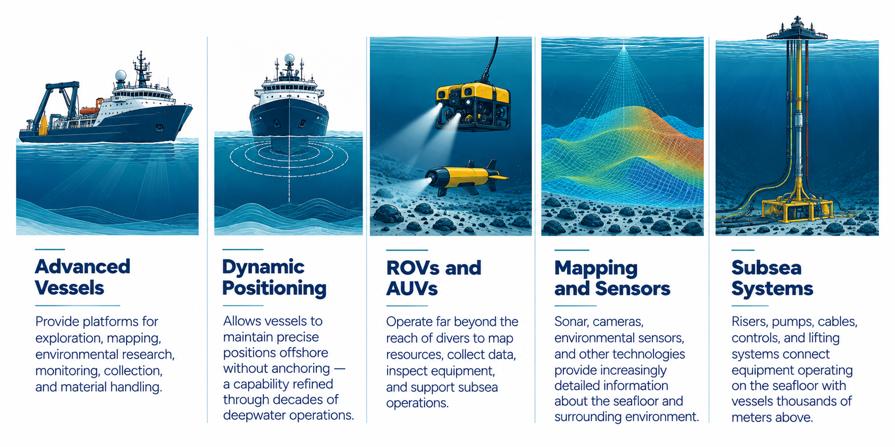
Advanced Vessels
Provide platforms for exploration, mapping, environmental research, monitoring, collection, and material handling. Specialized vessels can support subsea equipment deployment, onboard research, data collection, and the movement of recovered materials.
Dynamic Positioning
Allows vessels to maintain precise positions offshore without anchoring — a capability refined through decades of deepwater operations. Computer-controlled propulsion systems use positioning data and environmental measurements to help vessels maintain station while supporting equipment operating far below the surface.
ROVs and AUVs
Operate far beyond the reach of divers to map resources, collect data, inspect equipment, and support subsea operations. Remotely operated vehicles (ROVs) are controlled from the surface, while autonomous underwater vehicles (AUVs) can carry out programmed missions using onboard navigation and sensing systems.
Mapping and Sensors
Sonar, cameras, environmental sensors, and other technologies provide increasingly detailed information about the seafloor and surrounding environment. These systems help characterize mineral deposits, map underwater terrain, establish environmental baselines, and monitor conditions during offshore activities.
Subsea Systems
Risers, pumps, cables, controls, and lifting systems connect equipment operating on the seafloor with vessels thousands of meters above. Depending on the collection approach, these systems may transport material to the surface, deliver power and communications, or support the operation of subsea equipment.
Engineering from the Seafloor Up
Spotlight on The Metals Company
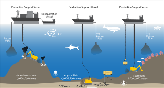
The Metals Company is developing an integrated system for recovering polymetallic nodules from the deep ocean.
Its approach combines a purpose-built seafloor collector, a vertical riser system, surface vessels, and material-handling technologies into a single system designed to move nodules from the seafloor to the surface.
Pilot collection systems have already recovered nodules at operational depths, providing real-world data that can inform the next generation of equipment and operations.
Deep-ocean mineral recovery is an engineering challenge — and engineers are already building and testing the systems to solve it.
Finding Nodules Without Touching the Seafloor
Spotlight on Odyssey Marine Exploration
Finding a resource does not always require physically interacting with it.
Odyssey Marine Exploration’s Benthic Acoustic Mapping and Characterization of Nodules (BAMCAN) approach combines multibeam sonar, acoustic backscatter, geological information, and environmental data to predict where polymetallic nodules are likely to occur.
The approach shows how existing offshore data, geophysical expertise, and advanced analytics can help characterize resources before additional seafloor activity occurs.
A New Generation of Autonomous Collection
Spotlight on Impossible Metals
Impossible Metals’ Eureka II demonstrates another approach to ocean mineral collection: autonomous underwater vehicles equipped with computer vision, artificial intelligence, and robotic systems designed to identify and selectively recover individual nodules.
During a 2024 deepwater demonstration off Florida, Eureka II operated approximately one mile below the ocean surface.
The technology illustrates how advances in autonomy, robotics, and machine vision can make future ocean mineral operations increasingly precise and selective.
Building on the American Offshore Advantage
The technologies may differ, but the foundation is familiar.
Advanced vessels. Robotics. Autonomous systems. Geophysical mapping. Subsea engineering. Sensors. Data analytics. Highly skilled offshore workers.
America has spent decades building these capabilities. Ocean minerals provide an opportunity to apply them to a new resource — while continuing to advance the technologies that allow us to understand and operate in the deep ocean.
That opportunity extends beyond mineral recovery. The same investments in offshore engineering, autonomous systems, oceanographic research, and subsea technology can strengthen capabilities across America’s broader maritime and offshore industries.
With an established industrial base and companies already developing and testing new technologies, the United States has a foundation on which to build a competitive ocean minerals industry.